The Trans-Labrador Highway

The weather is beautiful, sunny and warm.

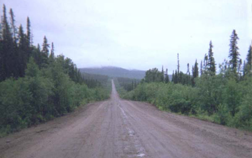
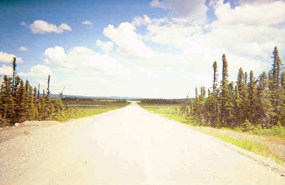
The Trans Labrador Highway is straight and flat with no potholes or washboard, but the gravel is coarse and loose and accumulates in drifts and ridges. If I can stay in a path which is packed and hard I can go pretty quickly, but if I wander into the loose sand my front wheel suddenly kicks out in a new direction. Sometimes the track I’m following is just a rut the width of a single wheel and sometimes it’s not even on the right side of the road; there is not much traffic coming the other way, a truck or two every hour, but when it comes it comes fast. After hours of this micro-navigation, of shifting back and forth between tracks and watching for sharp rocks and loose gravel banks, I no longer see the textures of the road but just the colors that represent them — I know the road’s palette, it’s become a painting and I thread my way among its hues. I learn the rules of a strange color game: to get to the end I must follow the silver road-within-the-road, I must cleave to the golden band or the cream bar.

I stop often in an effort to stay alert but when I do flies the size of quarters rise up and start circling. They are the most evil-looking flies I’ve ever seen, huge, black and chitinous as flying crustaceans with abdomens like grapes full of pus. They don’t bumble and wobble idiotically like flies should; no, they circle with the slow deliberate motions of other large predators — they are confident. If I am bitten by something that large I will die on the spot of a heart attack. I can’t stop for more than a minute before riding off in terror.

Every time I stop I hear the same bird. The low, dark trees are the same. The road is the same. The same evil flies rise up. This is not a diverse ecology. And every time I stop there’s a spent shotgun shell lying somewhere within sight. If my random sampling is representative then that would mean there’s a shotgun shell about every 30 feet. Assuming an even distribution along both sides of the road for its full 300 miles, that’s a lot of shotgun shells. Presumably they are the only thing effective against the flies.

After six long hours I reach Churchill Falls, almost halfway. I’d planned to stop and rest, have some lunch; instead I take five minutes to get gas, an Aero bar and a cup of coffee, then get back on the bike to do it again.


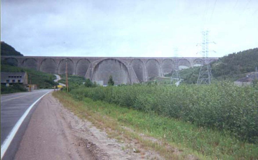
Churchill Falls isn’t actually a dam. Because there is a thousand foot natural drop here they didn’t have to build a dam, just divert the river through a set of underground turbines. It’s because of this that they came all the way out here to build it; I’m told that Churchill Falls supplies the power for New York City. They built a railroad from here to Goose Bay just to bring in the hydroelectric equipment, then the leftover railroad bed became the road.

In the afternoon I go fast, deleriously fast, faster than I’d thought possible. I can’t tell how fast without a speedometer, but it feels unreal, dreamlike. I float over the gravel. Partly it’s because the road is better, surely, but there must be something else — I feel like I’m developing a sixth sense, a Dirt Sense, because I’ve started making critical decisions unconsciously, just like in normal riding. I realize I’ve slowed down and then notice that the gravel’s become deep and loose; I see the trees whipping by and conclude that this stretch of road is firm and good.

Just before dark I roll into the city of Happy Valley-Goose Bay having completed in 11 hours what takes people around here only five. The paved streets are smooth as eggshell.

Labrador City, Labrador

The rain picked up again as soon as I started up the 100 mile dirt road. Although straighter than the paved road south of Manic 5, the packed dirt was thick with washboard and potholes filled with coffee-colored water. I bobbed and wove and slowly picked my way through them, getting wetter and colder as the sky got darker. About 60 miles in I gased up at Relais Gabriel, just a couple buildings huddled in the woods.

I’d hoped to finish the dirt section before I stopped but after four hours I was exhausted and could barely see in front of me; when I saw a bridge I jumped at the chance to throw my bag down under it.

It took an hour more to finish off the dirt the next morning and reach Gagnon. Gagnon used to be a town, but when the mine closed they bulldozed it so now it’s just an empty name marking the beginning of 50 miles of pavement in the middle of nowhere. Then the road turned back to dirt for another 40 miles, snaking back and forth, back and forth over the railroad tracks that appeared out of the woods and were also heading north. I had to stop for a train, a long line of open cars full of black sand going south: iron ore.

The Fermont mine looks like the end of the world, from vast north woods to lunar desert with no transition. Suddenly the trees peeled back and I was riding beside a sea of tan dunes. At first I thought it was just a sandy ridge until I saw a dumptruck the size of a pinhead and realized that my perspective was all screwed up; the horizon tumbled away from me. Further on there was a huge building/machine of belts and concrete silos, then great hills of loose red-black waste earth easily 20 stories high and extending out of sight. Then pavement again.

Labrador City was just a few miles further on but I pulled into the town of Fermont anyway, the first town I’d seen since the St. Lawrence. The heart of the town is a big strange building, a sprawling piece of sheetmetal that’s a combination mall/school/hotel and more. It’s a great idea for the winters to have everything indoors and connected, but stranger still is that the building was designed to act as a giant windbreak for the rest of the town which hunkers down behind it for protection from the northwest wind. I prowled its echoing concrete hallways and thrilled to be in civilisation. It had to be civilisation because it had women, and kids listening to headphones- I’d seen some people in the 350 miles since Baie Comeau but they were all men in trucks or men with equipment. Suddenly here in the woods was a place with a Sears catalogue store, a bank, a hardware store, an ice cream shop, two travel agencies. I ordered some gloriously hot food at a diner and spent 45 minutes smitten with my waitress; unfortunately she was not inclined to speak english.

But once I got back on the highway I saw signs saying that Labrador City had a Tim Horton’s, and that’s another thing entirely.


Everything up here has a purpose. Labrador City is the home of the world’s largest open-pit iron mine, and the neighboring Wabush and Fermont mines aren’t small either, each supporting their own town. Labrador City has 10,000 people and one way or another they’re all there because of the mine. The red hills that rise over the city are not natural, are not hills at all but great mounds of waste — the city is almost in the mine. Churchill Falls, the next town far to the east, is there to service the hydroelectric device. I don’t love mines anymore than I love dams, but in a world built out of metal that runs on electricity this is what’s going on behind the curtain, always. This is where it comes from. It was iron and electrons that got me here.

Labrador City has everything and feels like a normal town with shopping plazas, a movie theatre and a real mall. The people have normal houses, new cars, satellite tv and internet access; I’m told the mine pays well. The kids have skateboards and baggy pants and lurch around in mobs looking sullen. But before 1992 they didn’t even have a road to the outside world; it was then that the miners, while on strike, took the mining equipment and built the last 40 miles of road by themselves. That’s why it’s such a crooked thing, clinging to the established railroad bed — still, it’s a road.

Running east from here, connecting Labrador City to Goose Bay, is the Trans-Labrador Highway. It is 300 miles of loose gravel, and it’s most of the reason I came.

Manic 5

It was cool yesterday and I didn’t get started until noon, but it was still a nice ride up through the middle of the White Mountains, then over the gentler farmland of northern Vermont and finally onto the plains of Quebec with their squat sheetmetal buildings. I made it to just north of Quebec City for the night, then rode up the northern shore of the St. Lawrence this morning. The sun burst into silver flame on the water.

At one point the road stopped and at the end of it there was a boat. I pulled over and looked at my map; no, I hadn’t taken any wrong turns. I followed the cars onto the boat and in about five minutes we all drove off again on the other side of an inlet, where the road continued.

At noon I reached Baie Comeau where 389 heads inland. It’s an unremarkable medium-sized sideroad with nothing to mark it as the beginning of the only overland route to Goose Bay, 600 miles away. If you buy a Rand McNally or National Geographic road atlas of North America and look at the map of Canada you can see the road to Goose Bay, the only road that penetrates the interior of Labrador, the only road to Labrador at all. It forms a great big arc from the St. Lawrence to the Labrador Sea, going first north through Quebec and then east across Labrador. Much of it is marked by a dotted line: unpaved. Flip to the map of Quebec for more detail and you’ll discover that it only covers the southern part of the province, and the same happens if you buy a fold-out map of Quebec. In most atlases you won’t find a map of Labrador at all, even though it’s about the size of Oregon. I realize it’s just an economic decision made by the mapmakers- why double the size of your map just to show one road (two if you count the road to James Bay)? — but the effect is eerie, as though the provinces are somehow reluctant to claim the region. The best the Canadian information center at the border could give me was a photocopy of a typed page describing the road conditions broken down into segments; the first segment is from Baie Comeau to a place called Manic 5.

For the 125 miles to Manic 5 the road heaves violently up and down and side to side, just a thin ribbon of tar pasted to the cortex-like contours of the Canadian Shield. At 57 miles north of Baie Comeau my speedometer cable snaps, taking with it my odometer and my best way to judge when I need gas. Then again, from here on out the gas stations are about a tank apart anyway so I’ll just gas up whenever I see one. It’ll be a while before I can get a replacement cable.

It starts to rain and I get cold and discouraged very fast; would a full day of sunlight have been so much to ask? I’d packed in a hurry and nothing was sealed in plastic so I have to repack everything in the darkening rain. There’s no place to stop before Manic 5, nothing at all along the road except a few empty hunting cabins, no way to mark distance so I don’t know how fast I’m going or how far I’ve gone, I don’t know anything except trees and rain.

It turns out that Manic 5 is short for Manicougan 5, the name of the hydroelectric dam. It’s just a gas station and cafeteria set within a semicircle of motel-like rooms, just an outpost of the empire. Soaked and shaking, I get a big hot order of poutine (french fries with cheese and gravy) and try to warm up. There are pictures of the dam hung on the walls; I have no love of dams, but the road wouldn’t be here without it.

I have a photocopy telling me that the next hundred miles of road are unpaved gravel. The more I think about it the more it seems like a statistical inevitability that at some point along that 100 miles of dirt road I will go down. No matter how careful I am, eventually I’ll make a mistake: soft sand, loose gravel, a pothole or a corner too fast — something will happen and I’ll go down. I can’t scrutinize every foot of road for 100 consecutive miles; I just don’t have the attention span.

The only strategy I can think of is to ride so slowly that when I do go down I can get back up again. It’s five p.m. and I’ve been riding since five in the morning. I think about getting a room, but the rain seems to stop so I continue north.